Postglacial topographic response
Understanding the response of topography to glacial-interglacial cycles
Earth’s topographic form is controlled by interactions between tectonics, climate, and surface processes. Under constant conditions, rivers and hillslopes tend to adjust their gradient so that erosion rates approximately balance tectonic uplift rates. However, short-term perturbations in tectonics, climate, or surface processes may create a temporary imbalance between erosion and uplift.
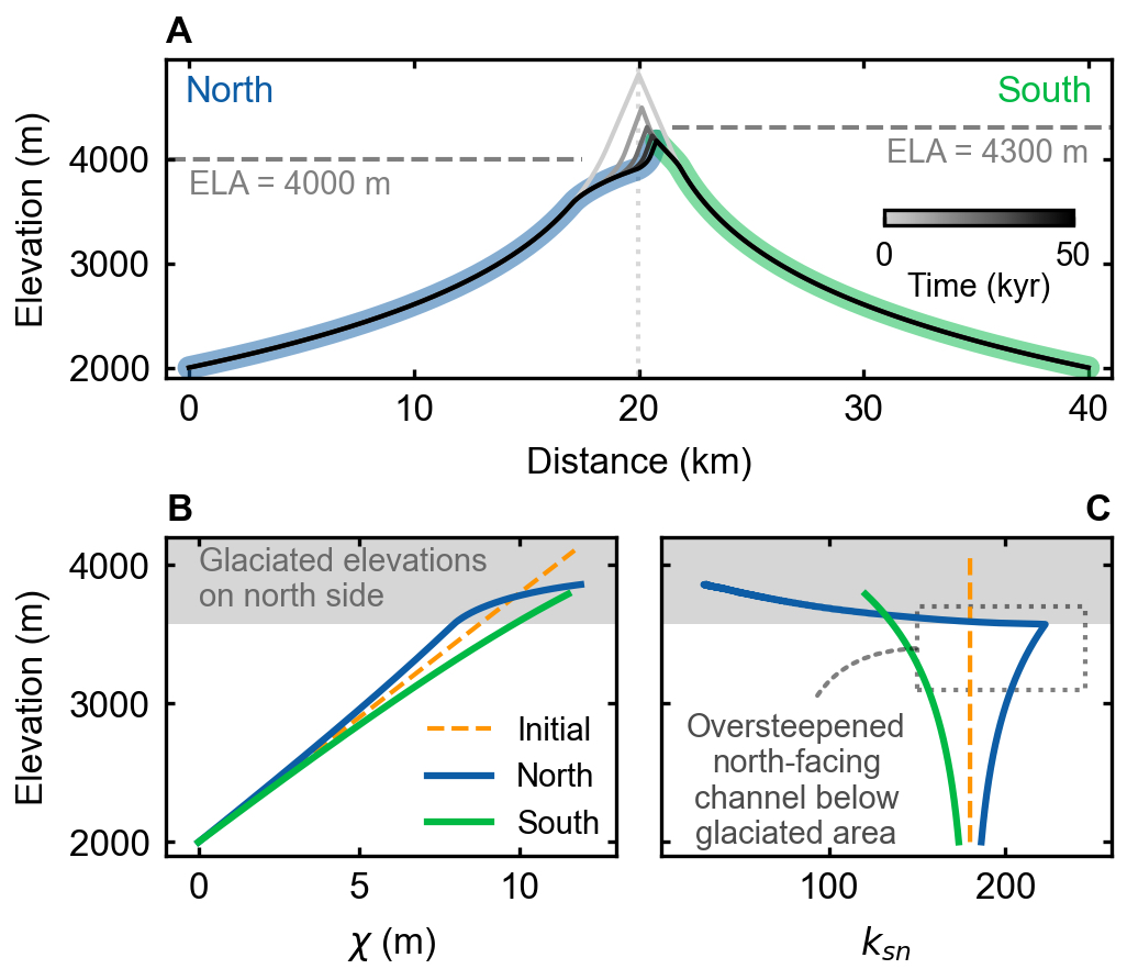
Repeated glacial-interglacial cycles during the Quaternary have acted as such perturbations in mid-latitude mountain ranges worldwide. Since the Last Glacial Maximum (LGM, ~25 thousand years ago), the transition from glacial to fluvial and hillslope geomorphic processes has induced progressive adjustments of topography in deglaciated landscapes, resulting in erosion rates that exceed or lag tectonic uplift rates. For example, rockfalls and landsliding of steep U-shaped glacial valleys grade hillslopes towards gentler, gradually eroding V-shaped fluvial valleys, and, in some places, progressive fluvial incision evacuates glacial sediments and dissects glacial terraces.
Understanding the timescales over which these adjustments occur before a new quasi-equilibrium between erosion and uplift is reached is a key question for understanding how Earth’s topography responds to periodic climatic perturbations. If landscape response times exceed typical durations of Quaternary interglacial periods (~20-50 thousand years), then mid-latitude mountain ranges may be persistently adjusting and never reach an equilibrium before the next glaciation occurs. On the contrary, if their response times are shorter than interglacial periods, then Quaternary glaciations may only fleetingly disrupt long-term tectonically driven landscape evolution.
POSTCOLD - Understanding the influence of sediment dynamics on postglacial landscape evolution
This project is funded by a Marie Skłodowska-Curie Postdoctoral Fellowship.
In recently deglaciated landscapes, the transition from glacial to fluvial/hillslope processes have induced progressive topographic adjustments, and the large amounts of sediments inherited from glacial periods and generated through landsliding of oversteepened glaciated topography may act as a fundamental control on the incision of postglacial rivers. These sediments can enhance fluvial incision rate by providing more tools for erosion, or inhibit incision by armoring the river bed. Characterizing when and where sediment enhances or inhibits fluvial incision in postglacial landscapes is critical for understanding the changes in postglacial landscape evolution rates over time and quantifying the response times of mountain ranges to deglaciation.
In this project, I propose to develop a landscape evolution model to account for the complex impact of sediment dynamics on fluvial incision in postglacial landscapes. I will utilize this model to investigate the response of fluvial incision to changes in sediment supply and assess the effects of sediment on postglacial landscape evolution. I will apply the model to quantify response times of the deglaciated European Alp, leveraging the rich observational datasets in this region. The proposed work will provide a quantitative understanding of postglacial fluvial incision histories, which is critical for ecosystem management and natural hazard assessment in recently deglaciated mid-latitude mountain ranges and perhaps in high-latitude mountain ranges where continued climate change may eventually lead to deglaciation.
Postglacial fluvial network expansion in glaciated plains
Landscapes of the US Midwest were repeatedly affected by the southernmost portions of the Laurentide Ice Sheet during the Quaternary. Over much of the Midwest, depositional glacial processes diminished pre-glacial relief by filling valleys and left constructional landforms including low-relief till plains and high relief moraines. As the ice retreated, meltwater collected in subglacial or proglacial lakes leaving fine-grained, sorted sediment in the form of glacial lake plains. Glacial lakes episodically drained in outburst floods, carving deep valleys.
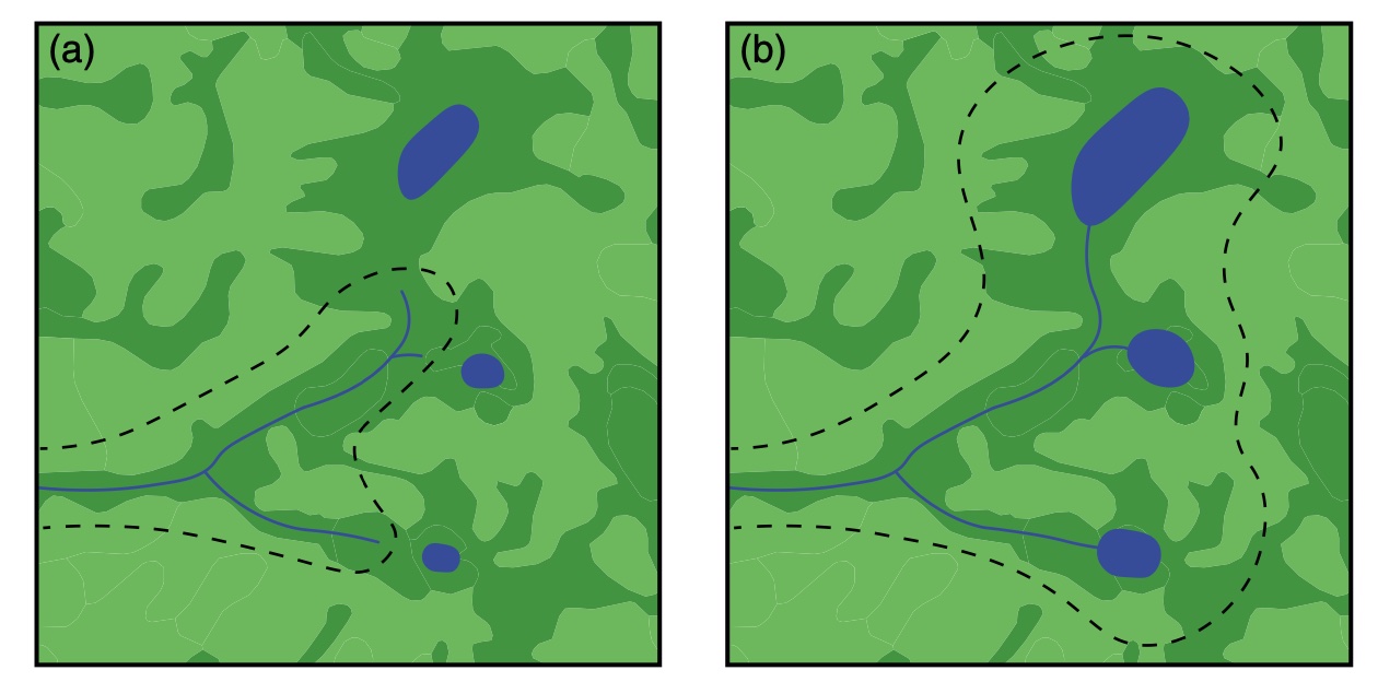
However, meltwater valleys did not provide a landscape-wide integrated drainage network. Instead, a significant fraction of the area of low-relief till plains and glacial lake plains was occupied by closed depressions and remained unconnected to external drainage networks. This area is referred to by hydrologists as non-contributing area (NCA) because it does not typically contribute surface runoff to stream networks. NCA becomes integrated into external drainage networks over time.
By combining numerical simulations with field observations, our research found that rates of postglacial fluvial incision and drainage network expansion are controlled by the hydrological connection between the poorly-drained postglacial plains and the growing river channels (Lai and Anders, 2018, JGR), and the hydrological connection can be achieved via filling-spilling of small lakes or groundwater (Cullen, et al., 2021, ESPL).
Related publications:
-
Sediment Dynamics Control Transient Fluvial Incision - Comparison of Sediment Conservation Schemes in Models of Bedrock-Alluvial River Channel EvolutionESS Open Archive, 2023Preprint

